Claviere Map Download 👇
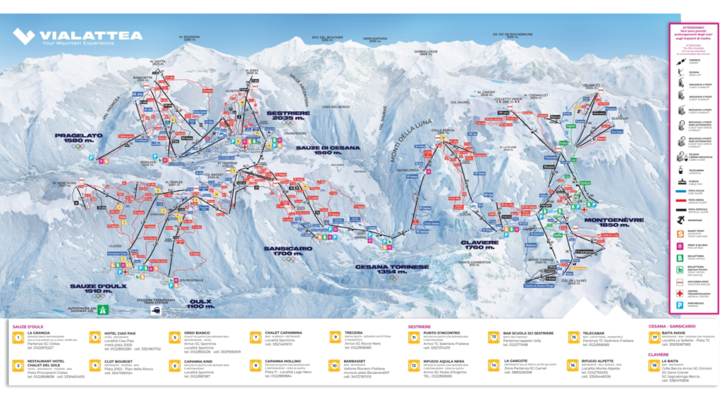
Claviere Ski Map
Clavière is a charming border village ski resort in the Via Lattea (Milky Way) ski area, sitting right on the edge between Italy and France. It offers a quieter, more traditional alternative to the larger nearby hubs, with tree-lined slopes and a relaxed alpine atmosphere. Because of its position at the far western end of the ski network, it also acts as a key gateway into France via Montgenèvre, making it feel wonderfully international for such a small resort.
What makes Clavière especially appealing is its easy-going terrain and uncrowded pistes. The skiing here is smooth and accessible, with plenty of gentle runs that are ideal for beginners and families, while intermediates can enjoy linked cruising routes across the border. It’s not about steep extremes or massive vertical drops, but about relaxed skiing, scenic surroundings, and seamless access into the wider Via Lattea system.
Total Ski Area: 400 km / 249 miles (Via Lattea network)
Base Elevation: 1,760 m / 5,774 ft
Peak Elevation: 2,789 m / 9,150 ft
Difficulty:
🟦 45% Easy
🟥 45% Intermediate
⬛ 10% Advanced
Ski Season Length and Dates
Typically the ski season runs from late November – early April (conditions permitting).
Is it good for beginners?
Yes – Clavière is very beginner-friendly. It has gentle nursery slopes, quiet pistes, and a calm village environment, making it an excellent place to learn skiing or snowboarding comfortably.
What’s included in the Ski Pass?
- Full access to the Clavière ski area within Via Lattea Part of the wider Via Lattea (Milky Way) ski network Cross-border access into Montgenèvre (France) via linked lifts Access to interconnected resorts:
- Sestriere
- Sauze d’Oulx
- Sansicario
- Cesana
- Clavière
- Pragelato
- One ski pass covers the entire Via Lattea network (no separate resort tickets required)
- Local Clavière-only passes available as a cheaper option
- Full Via Lattea pass recommended for maximum exploration across Italy and France
Ski Pass Overview Table
| Feature | Details |
|---|---|
| Ski Area Access | Yes – Via Lattea network |
| Main Base Resort | Clavière |
| Total Ski Area Size | 400 km / 249 miles |
| Location | Italy–France border |
| Resorts Included | Sestriere, Sauze d’Oulx, Sansicario, Cesana, Clavière, Pragelato (+ Montgenèvre with full pass) |
| Pass Options | Local Clavière pass or full Via Lattea pass |
| Best Option for Beginners | Local Clavière pass |
| Best Option for Exploration | Full Via Lattea pass |